Showing posts with label Christopher S. Bond Bridge. Show all posts

Sunday, July 3, 2011

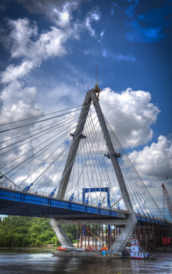
Bond Bridge Fully Lit


Bond Bridge illuminated its LED lights along the sides tonight. They can be almost any color and move.... sliding red right to left, blue left to right, white from middle to sides.... very interesting.... makes for a very dynamic structure. Also another, much longer, fireworks display tonight from Riverfest.... good evening all round! Here's a link to a brief iPhone video of the fireworks... and you can see the LEDs changing. http://gallery.me.com/dremley#100622

Monday, November 22, 2010

Bond Bridge First Lighting


I was privileged to be riverside as the first set of Bond Bridge lights were turned on for the first time. Each of the cables is illuminated individually with cannon spots. Later on the L.E.D. lights will be turned on along the sides of the deck. Those can be any color and even controlled individually. The Bridge was completed six months early and the Paseo Bridge was retired last Friday. It really is gorgeous. I can see lots of riverside visits in my future. This shot is looking northwest and was taken at 6:15pm. It is seven shots at varying exposures sandwiched for the final product. Nikon D3 was tripod mounted, ASA 1000, Nikon 14-24mm set at 24mm.

I was going to post Part 2 of the Pendleton Heights Holiday Homes Tour tonight, but I will postpone that until tomorrow.

Monday, August 2, 2010

Walking by the Mighty Mo

Tried the new river walk on Sunday..... which allows a person to travel from Main street almost all the way to Paseo Boulevard along the Missouri River.
Above looking east toward the ASB Bridge, below looking west toward the Broadway Bridge. Old mooring post in the foreground below with wire rope still attached.And yes, the Mighty Muddy Mo is Mighty Muddy. As Twain said: "too thick to swim in and too thin to walk on."
Above the ASB Bridge which stands for Armour (Packing Co.) Swift ( & Company) and Chicago, BURLINGTON (and Quincy Railroad). The piers were built in 1890 but sat unused until 1909 when construction of the rest of the bridge began. It consisted of two decks the upper for cars and trucks and the lower for trains. The bridge, as you can see, is very close to the surface of the water right now which is one reason why the center portion is counterweighted and can be raised. Bridge designers made it possible to do this without disturbing the top deck so traffic was not impeded. After the Heart of America Bridge was finished in 1987 the ASB's top deck was removed. It is a National Landmark in Civil Engineering and is owned now by the Burlington Northern Railroad. Note the pathway goes down under the bridge....on the right in the image. The path is handicap accessible and is for biking or walking.
Areas next to the trail have been planted with native grasses and other plants which should make it look a lot like it did when Lewis and Clark came by just after 1800.
Above, ASB on the left showing one of the massive piers. The piers were originally 9 stories tall in 1890 when completed but were lowered to just 10-feet over the high water mark.
Another view of the Bond Bridge looking east above and below the ASB and The Heart of America Bridges.

Below.... "adaptive reuse" sorta. An old administrative building which was in horrible shape has been stabilized and even has flower boxes in the windows.
To access the walkway you can take Grand down to Berkley Park and then walk west, or, park at the foot of Main, walk out on the tower and then down by stairs or elevator to the walkway.

Saturday, July 31, 2010

South Shore Awaits

Journeyed down to the rivers edge to check on the Bond Bridge construction. Tons (literally) of progress to report including the fact that it's almost shore to shore. Very small, relatively speaking, space to go before the span touches north and south banks. Above is the view from above the Isle of Capri fake water feature.... the casino takes river water and pumps it through their grounds and then that circuit is complete with the return to the stream shown above.
Above a panorama under the south end of the bridge showing the only gap that remains to be closed. Paseo Bridge is on the left. The new bridge is scheduled to be finished by this time next year.

The north end was constructed using steel supports.... after the midpoint was reached the southern half of the bridge was cantilevered out since the river channel had to be kept open for barge traffic. The river's high level this year has slowed progress somewhat since much of the work is done from barges which also bring a lot of the supplies out to the work site.

When finished and illuminated by thousands of led lights that will be computer controlled the bridge will be stunning...


The top of the delta pylon is roughly 316 feet above the river's surface....

As mentioned previously tugs, like the one pictured above, scurry around the supports of the structure all day.
The remaining gap between in the bridge near the south shore seen above. Below, that same gap from the endpoint.

Above and below the deck will soon stretch completely across the river.... in the above photo you can see the small crane atop the delta pylon which ferries men and equipment to the top.

Friday, April 9, 2010

Progress on a Bridge to Somewhere

Enough progress has been made on the new Bond Bridge that, according to the STAR, some northbound traffic may use it by the end of 2010. The bridge's south deck is being cantilevered out from the central pylon... 40 cables will eventually support the road bed... you can see that several have already been installed in the center. Total completion of the bridge won't be until June in 2011. (correction by Mr. Daisy... July 2011)

Picture taken yesterday from Prospect Point by Reservoir Hill in Northeast KC>

Tuesday, March 16, 2010

Hyper Is Out On Bond


The Christopher S. Bond Bridge is under construction right next to the Paseo Bridge it will replace. Suspended by a delta-shaped pylon the new Missouri River Bridge, shown below, will be a two-span structure with a 550-foot main span and a side span of 451 feet. The top of the pylon will be about 316 feet above the average river level. (Image below and at the conclusion of the post courtesy of Bradley Touchstone)
The process for constructing something this massive has always fascinated me. Through the kindness of Laura Wagner, Information Officer for the construction side of the project, I got to take a closeup look at the site. Below is the sign and building for KCICON the project management team.

The 245 million dollar project is more than just the bridge... it will also widen the I-29/35 corridor from two lanes in each direction to three. As shown on the map below the contruction spans a 4.7 mile section of roadway from just north of Armour Road to the northeast edge of the downtown loop.
Laura, below, displays one of the thousands of bolts that will hold this bridge together... and the second pix below shows a section of rebar that will reinforce the concrete deck of the bridge.. 235 miles of rebar to be exact...


Above new and old side by side Paseo Bridge on the left and Bond on the right. Below, view from the base of support columns for both. Pylon visible in the center.

The new river bridge will be 124-feet wide (left above) capable of carrying eight traffic lanes and a pedestrian/bicycle path.... the additional lanes and path would require future work to widen connections to the north and south of the structure. This widening is not in the current budget.
Large steel supports footed in concrete support the north section of the bridge... eventually the superstructure will be supported by 40 stays radiating in a semi-fan arrangement from the pylon.

Above, looking south, Bond, Paseo and City.
Below and above... the new bridge, at its closest point, is only six feet from the existing Paseo Bridge.

Above... steel structure being put in place prior to the precast concrete slabs being dropped into place to form the base of the bridge deck.

Deck is composed of precast concrete sections lowered into place. Rebar is then put in place and covered with concrete... then another layer of concrete comprises the road bed.


Above... precast concrete slabs being delivered to the site before being craned into place on the deck.

50,000 cubic yards of concrete will be used in the project along with 8 million pounds of steel.
The pylon was to be "topped" last week... huge cranes, one brought in from Amsterdam, are needed to reach the 316 feet to the "point."
Barges and their tugs are an essential element in delivering materials to the bridge as well as acting as anchored bases for the cranes.

Once the northern half of the bridge is complete the southern half will be cantilevered out a section at a time from the central support. Steel support columns will not be used for this half as the navigation channel in the river cannot be blocked.


Hyper doesn't like heights but they don't bother the iron workers... I envy their fearlessness...
Above another view from the south bank of the Missouri showing the temporary steel supports under the northern half of the new bridge.

Above and below.... when I say barges and tugs are essential... I mean it... note the PortaPotty being barged out and then craned into place. Construction on the MoDOT project broke ground in April of 2008 and is scheduled to be completed by July 31, 2011. The bridge will be lit at night using lights that can display a single color or a series of colors that can result in an unlimited variety of lighting combinations. Once the new bridge is up and running the old Paseo Bridge will be torn down.